30 June 2023

About me

Hello again. It is amazing how fast time goes. Life can give a person whiplash sometimes, especially with a quick turn on the class schedule. It is always good to see familiar names. My first name is Jerome but I go by Chris. I have just finished GIS Programming in the first half of the summer term. That was one of the toughest classes I have taken since Statistics. I am enrolled in the Master's GIS Admin program which is very exciting but a bit overwhelming at the same time. I have enjoyed my GIS adventure so far. There is always so much to learn. I had courses in GIS many years ago but that was such a long time ago now. 

I live in Pensacola and work from home for the UWF Bookstore full-time. Upon completion of the program, or before, I hope to move over to a GIS job and perform GIA analysis until I am no longer able to.  Meanwhile, I look forward to being able to help in this class when I can. I wish you all the best of luck.

https://storymaps.arcgis.com/stories 

27 June 2023

M6 Working with Geometries

Script results
Text file
ArcGIS output

Pseudocode

Start 

Set up

Prepare to write text file

Create(write) text file

Create variables

Field 1 = Feature/row OID 

Field 2 = Vertex ID 

Field 3 = X coordinate  

Field 4 = Y coordinate 

Field 5 = Name of the river feature 

Create for loop

Close text file 

Delete row and cursor variables outside of all loops

Stop


Flow chart

This week’s assignment was the culmination of the last six weeks of working with scripts. We worked with geometries and covered the topics of Nested loops, Search cursors, For loops, Writing to a TXT file, and Creating loops within a loop. It was a challenge to put together but using information and script templates from previous assignments helped me compile scripts to deliver the results. It is one lengthy script made up of several smaller ones. I had struggles with indentation and syntax specifically when writing the data to the text file which required a series of “for loops”. In the files above you can how the same results are different when they are viewed.


As I said it helps me to keep a notepad of scripts we must use to complete exercises. This week was consistent with previous weeks of reminding me to read through each script to ensure better understanding. This allows me to make mental notes of proper syntax. I created a notepad of scripts from completed exercises before beginning the assignment. This is very helpful in narrowing my focus to the script and helps me to understand it better. For this assignment, I went back to exercise 5’s scripts I saved as notes to get me going. Courses such as this have a way of “forcing “ me to be better organized and to find the greater detail in the details.


18 June 2023

M5 Explore and Manipulate Data


Scripts results
Module Flowchart


This week's module was exciting to put together and run.  For the assignment, we had to set up a workspace, create a file geodatabase (fGDB), list all feature classes while assigning the list to a variable, copy features from the Data folder into the new fGDB, create a Search Cursor for the cities feature class, create an empty dictionary named county_seats, and populate the dictionary with the names (keys) and populations (values) of all County Seat cities. It was a lot of information that went into the assignment and then making sure all of the details were correct was time-consuming. 

Once again the task of creating a script was a matter of following through on the exercise step-by-step. I am the person that has to go by the numbers and programming is certainly built that way. Ensuring the syntax, tasks, and verbiage are all inputted correctly is rewarding when the output is as it should be, mostly. I had trouble with using the two formats for adding pairs to a dictionary from the assignment. The formula is given to us from the assignment but I just could not get it to work, even though I tried many different ways of adding the information. 

14 June 2023

M4 Geoprocessing


Geoprocessing script result

Model build with tools used at the top

Map output of the model build


This week's module took me into geoprocessing, model building in ArcGIS, and, of course, more Python scripts. There was some editing of scripts to get the desired results as I needed to be sure I was using the correct folder for the results and not simply saving everything to the same folder. 
In building the model I had to open the toolbox under the analysis tab and then click and drag the desired tool to the model builder. The challenge was getting the order correct, the input and output features, and what is being clipped and by what. Once I finished this part I needed to write a script for geoprocessing. The scripts were for creating a buffer around a shapefile, dissolving the buffers into a single feature, and finally adding XY coordinates to the shapefile. 
On this side of things, with it all completed, it is easy to say it was not too bad but when something is wrong in the format, file path, or some unfamiliar error it can be frustrating. As time has gone by in this class, I have found it to be rewarding and enjoyable to be challenged with different material.

07 June 2023

M3 Debugging and Error Handling

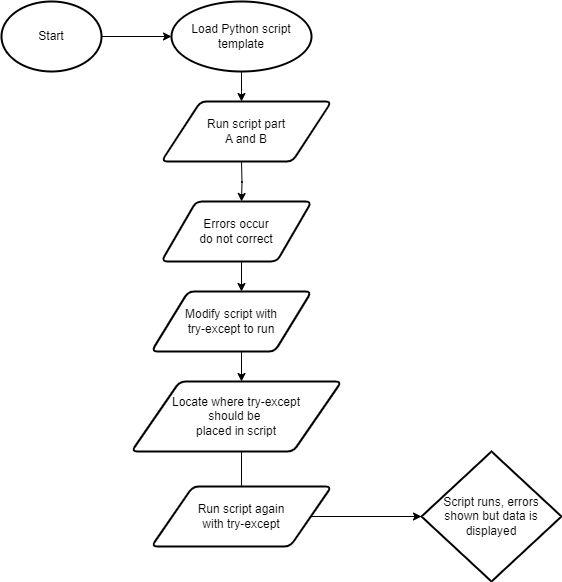
This week's module challenged us to find more errors and added a try-except statement to bypass an error in a script. This accounts for the error and still prints (displays) the data. I cannot say it has gotten easier "dealing" with Python programming but things certainly make more sense when I see and am able to correct errors. When presented with a script pause to look at it before running it, and pick out obvious errors that are present. Of course, the caveat is when the script runs, errors will present themselves where they were not visible before. 

The errors in the script could be misspelled words (ex. reference vs. reference or map vs. maps) or punctuation. Whatever they may be that is the point of each week's assignment and it never disappoints to frustrate and once scripts run correctly, feel the great thrill of victory. We had three scripts this week to find errors and run correctly, one of which introduced a try-except statement that accounts for the error but still runs. As Dr. Morgan and also in Agarwal's readings have reiterated several times, flow charts help create a path of enlightenment through the process of writing, editing, correcting, and completion of running the script with the correct response.

Script 1 results


Script 2 results


Script 3 results


Try-Except flow chart


UWF Student. Aspiring GIS Analyst.

Key takeaways from a GIS job search

  A job search can be daunting, time-consuming, and frustrating. There are words to add to that short list that are more-or-less synonyms of...